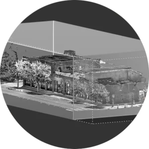
A building’s digital twin combines whole-building reality capture with information about building systems and features in one easy-to-access place, saving you time and headaches.
GreenLight 360 combines data from mobile mapping, terrestrial laser scanning, drone photogrammetry, additional photos, and information about your systems and building features to create accurate digital twins of your buildings. This can be especially helpful when you’re managing a maintenance or remodel program.
For example, you can easily set a point of interest within your digital twin at a precise location and enclose information for maintenance personnel to reference onsite. And GreenLight 360 hosts your digital twin in the cloud, giving you access to all of your building’s data from anywhere.